1890s ARKANSAS RAILROAD MAP
1). [Arkansas] Map Showing the Land Grants of the St. Louis, Iron Mountain & Southern and Little Rock & Fort Smith Railways in Arkansas. Little Rock, Ark.: A.N. Kellogg Newspaper Co. [Circa 1885-1895?] Color map 30 c 34 cm folded into cover 7.5 x 13.5 cm. Title in upper margin: Arkansas. Cover title: The Garden and Orchard of the Southwest. Map of Arkansas. Issued by the Land Department of the Iron Mountain Railway, Little Rock. On back of cover: “Steer” for Arkansas via the Iron Mountain Route. Pencil name on cover, else very good.
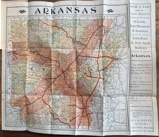
OCLC shows two holdings (UT-Arlington & Yale). Shows counties, railroads, railroad land grants, cities, and towns. In right margin: “Map showing the land grants of the St. Louis, Iron Mountain & Southern and Little Rock & Fort Smith Railways in Arkansas” [and additional text consisting of land advertisement directing interested parties to:] “G.A.A. Deane, Land Commissioner, Little Rock, Arkansas.” Date range of map determined from changes in county names and boundaries.
STREETER LETTER TO TEXAS BOOKSELLER
2). [Book Collecting][Texas] Streeter, Thomas. W. Typed Letter Signed to Texas Bookseller Clark Wright. One sheet, 15 x 22.5 cm. On his Morristown, N.J. letterhead. January 3, 1955. Thomas Streeter was one of the most famous book collectors of his generation and he amassed an impressive Texas collection, in addition to his collection of Americana. In this letter to Texas book dealer Clark Wright he declines certain Texas materials. “I am still interested in earlier and rarer items on Texas and will always be glad to have you quote them to me.”
BROWNSVILLE PROMOTIONAL
3). [Brownsville] Points of Interest in and Around Brownsville. [Brownsville, Texas]: Chamber of Commerce. [Circa 1931] One sheet 31 x 47 folded to 10 x 23 cm. Map: Tourist’s Map of Brownsville Showing Location of the Principal Places of Interest. Few small stains and edge wear, else very good. OCLC shows two holdings (UT-Austin & Hou. Pub. Lib.) Baylor has a 1933 edition. Shows some 37 sites, including Porfirio Diaz’ home, train depots, typical citrus grove, General Taylor’s Headquarters, etc.
UNRECORDED BROWNSVILLE PROMOTIONAL MAP
4). [Brownsville] Brady’s Detail Map of the Lower Rio Grande Valley. Chicago: National Printing Co. for Brownsville Chamber of Commerce. [Circa 1930] Map 46 xc30 cm. Along top edge: Brownsville International Air Port and Brownsville Deep Water Port, with information about both. One small split at fold else very good. OCLC shows no holdings for this map. Shows county lines, railroads, paved roads, gravel roads, graded roads, state highways, U. S. highways, proposed ship channel.
1916 TEXAS MEXICAN BORDER VIEWS WITH LETTER
5). [Brownsville] Barrett, T. J. Texas-Mexican Border Views. Brownsville, Tex.: T.J. Barrett. [Circa 1916?] Pictorial wraps. Ten views in portfolio. 18 cm.
OCLC shows two holdings (SMU & U. Ariz.) There is a brief “letter” home in pencil on back of the postcards describing what he had been doing on the Texas-Mexican border while stationed there. On the last card he states that he and some guys killed a pregnant rattlesnake that was 7’ 10” long and he had it skinned and tanned. Images include Brownsville and Matamoras on Rio Grande; International Bridge; Mexican Bridge Guard; On Guard, International Bridge; U.S Army Entrenchment; Typical Mexican Water Cart; Primitive Corn Mill; Native Family and Typical Jacal; Cart with Oxen & Rattlesnake.
1853 COYOTEVILLE CALIFORNIA GOLD MINER LETTER
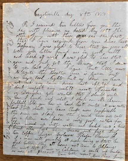
6). [California] Pine, Moses Jr. Autograph Letter Signed. Coyotieville, (sic) California. August 8, 1853. One page handwritten in ink on blue paper. 8 x 10 in. Folded, some stains. Legible writing. Interesting letter about living conditions and food in the now vanished mining town of Coyoteville, an extraordinarily rich gold area in the early 1850s. Rare to find a document from this mining town which existed for only some two years. A tunneling method, nicknamed “coyoteing” was developed there, leading to the town’s name. – Hoover, Historic Spots in California, p. 258. The letter mentions sending money home and discusses the weather, (dry!), sleeping on the ground with a coat for a pillow; food being “rather poor” flour mixed with water and baked into “a kind of bread,” also pork, ham, beans, fresh beef, tea, coffee, sugar, molasses, potatoes, & onions. “If a man will grumble at such living he had better stay home not come to California. The most I miss in California is milk and butter.”
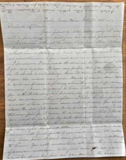
1855 CALIFORNIA MINING LETTER
“It would astonish you to see what has been done in California in the five years that Yankees have been here.”
7). [California] Owen Taft. Four Page Autograph Letter Signed. Table Mountains, California. Oct 22, 1855. Blue lined paper. One sheet 39 x 24.5 cm folded into four leaves. Very legible ink writing. Has been folded, else very good.
Letter to a friend back home in what is almost certainly Windsor County, (Woodstock) Vermont, as it references him getting copies of the Independent newspaper, published in Woodstock, and the Quechee River. He describes his California location as the foothills of the Table Mountains, 12 miles from Hamilton [in Butte County, founded as a mining town in 1848, now a ghost town] and 75 miles from Auburn. After discussing some on-going business matters in Vermont, the majority of the letter has very interesting content regarding coal and gold mining and his life in California including brief descriptions of the gold and coal mining efforts, lawlessness, dangers including wolves and rattlesnakes, weather, wildlife, missing home and family, etc. More than 1200 words. Transcript available. $
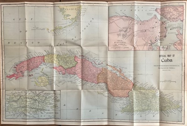
UNRECORDED CUBA POCKET MAP
8). [Cuba][Spanish American War] Official Map of Cuba. Chicago: The Fort Dearborn Publishing Co. [Circa 1899?] Color map 32 x 50 cm, folded in covers 14 x 9 cm. Inset maps: Puerto Rico and City of Havana and Harbor, showing “U.S. Battleship Maine blown up Feb. 15, 1898,” along with fortifications. Verso: Map of the World on Mercator Projection. Front cover detached and with paper loss. Map very good.
OCLC shows no holdings for this map. Cover title: Pocket Map of Cuba, Porto (sic) Rico and the World. Compliments of The Cuba & Pan American Express Co. 52 Broadway, New York. Rear cover depicts headquarters building of the Cuban & Pan-American Express Co.
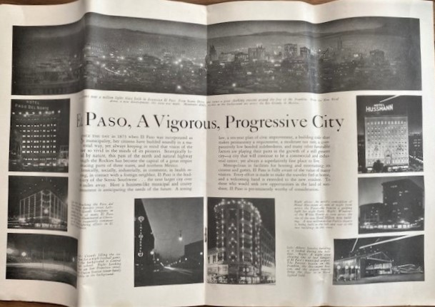
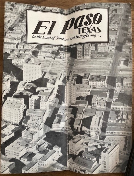
EL PASO PROMOTIONAL
9). El Paso Texas. In the Land of Sunshine and Better Living. [El Paso?]: El Paso Chamber of Commerce and El Paso Gateway Club. [1929.] Pictorial wraps. 22 x 288 cm. Illustrated. Map. [24] pp.
OCLC shows five holdings (El Paso Pub. Lib.; SA Col.; SMU; Tulane & U. Chicago.) Many historic photographs and information on El Paso and mentions Juarez. $
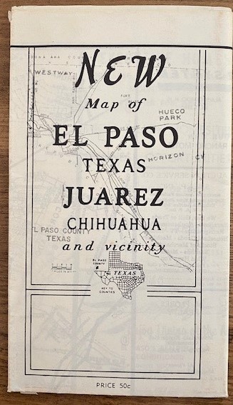
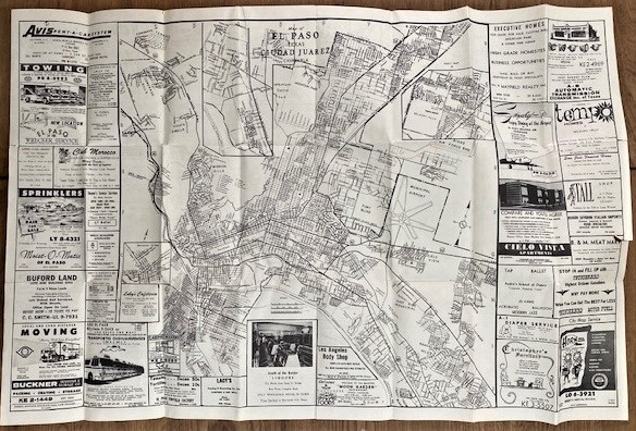
EL PASO FOLDING MAP
10). [El Paso] New Map of El Paso Texas Juarez Chihuahua and Vicinity. [Cover title]. [Place of publication not identified]: [Publisher not identified] [1950s?] Black and white map 59 x 88 cm folded to 11 x 20 cm. Map title: Map of El Paso Texas Juarez Chihuahua. Ads on each side. On verso map of Ysleta and ads and index. Map has two edge tears else very good.
OCLC shows one holding for a similar map (UTEP) although it is larger. The advertising gives an interesting snapshot of businesses on both sides of the border. $35
EL PASO FOLDING MAP
11). [El Paso] Official Arrow City Map, El Paso and Vicinity, Texas and Ciudad Juarez, Mexico. [Cover title]. Boston, MA: C. L. Polk [Circa 1960s]. Black and white map 70 x 107 cm folded to 12 x 23 in cover 12 x 25 cm. Index at bottom. Verso blank. Map has been detached from cover with small tear at corner, else very good.
OCLC shows two holdings (U. Chicago & Biblio. Paris). Showing all streets, main thoroughfares, highways and points of interest with street finder. Distributes by Sandoval News Service, Inc. El Paso, Texas. $
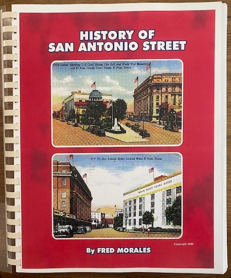
EL PASO LOCAL HISTORY
12). [El Paso] Morales, Fred. History of San Antonio Street. [El Paso]: Privately published. 2009. Spiral bound. 28 cm. Illustrated. 101 [1] pp.
OCLC shows no holdings. “[T]his … book [is] one of the most fascinating items in my library – and I have a lot of books on my shelves. Whether we know it or not, San Antonio Street – created and opened in the late 1850s – is a primary historical key to early-day El Paso.” – Leon Metz, El Paso Times. $
1896 ALAMO BOOKLET
13). [San Antonio][Texas Rangers] Ford, John Salmon. Origin and Fall of the Alamo. March 6, 1836. San Antonio, Johnson Bros. Print. Co. 1896. Second printing. Tan pictorial wraps. 23 cm. Illustrated. 39 [1] pp. About fine.
OCLC shows 22 holdings of this edition. Raines p. 85. CBC 340. Rader 1427. All of these early editions are scarce. Written by one of the committee members of the Alamo Association, Texas Ranger John S. Ford, fills the gap of events that took place before and during the fight at the Alamo, a historical event viewed by most as a pivotal site of conflict between the U.S. and Mexico: “During the night the enemy kept up a continuous fire. They placed men on tops of houses in their possession. They cut loop-holes in the parapet walls of the houses.” Contains several illustrations and photographs of the Alamo. $